The Raven South Atlantic Coast map might almost be titled “the Florida Peninsula and neighboring territories”.
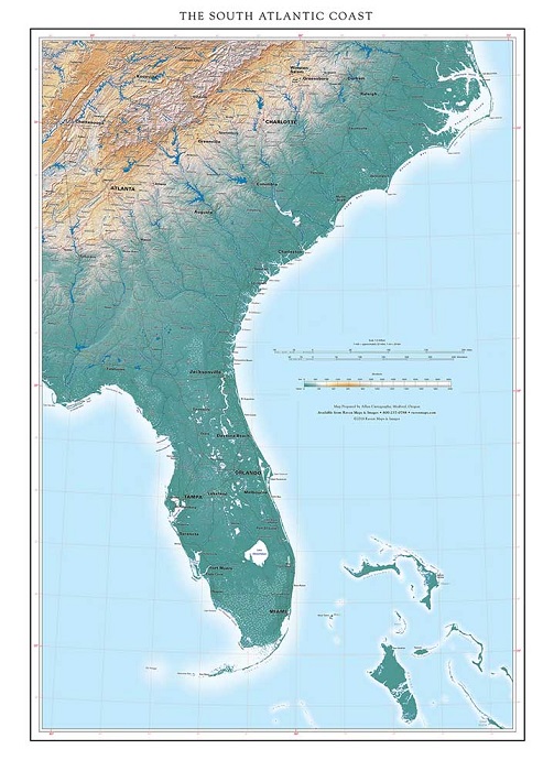
Florida is a uniquely conspicuous feature on any map of the 48 states, dominant on this one, and a complicating feature for regional map layouts. The entire state is included in Raven's Gulf Coast Map, so we feel less apologetic about cutting the western Florida panhandle off at Cape San Blas. The Peninsula is a flat limestone platform, more closely akin to the Bahamas than to the Appalachian ridges and Piedmont country to the north. Limestone dissolves in water under the right climatic conditions; the Florida peninsula is the land of sinkholes at the local scale and of innumerable lakes at the state scale, but very few rivers. (This “land of lakes” pattern is similar in appearance to that of northern Minnesota, but the respective origins of these landscapes could hardly be more dissimilar).
Florida's South Atlantic coastline of endless smooth arcs changes character abruptly just north of Jacksonville. The Sea Islands extend from Amalia Island just south of the St Marys River, and Cumberland Island just north of it, along all of the Georgia coast and the South Carolina coast up to the Santee River. This belt of winding tidal channels and marshlands, extending well inland along many river bottoms, made for prime pirate country in the 17th and 18th century. Caribbean connections were fundamental: South Carolina was settled in part from Barbados, Charleston was the center of a slave plantation, and the state’s enthusiasm for secession in 1860 reflected that circumstance. Geography does not determine history, but it counts.
North of the Santee the coast reverts to smooth arcs again: Cape Fear, Cape Lookout, and finally Cape Hatteras, a point on the sweep of long narrow sand bars enclosing Pamlico and Albermarle Sounds. These apparently fragile barrier islands are remarkably resilient— the currents that maintain them are fundamental and very long term forces of nature. Hurricanes can temporarily disrupt and shift them, but the islands remain. (Buildings sitting on them are another matter entirely).
The Sounds are, paradoxically, the source of an enduring legend with distant connections. Verrazano reported seeing them in the 1550’s, but could not pass the barrier islands, nor see any mountains to the west. Could this great bay lead to the Pacific? No one had any idea how far away the Pacific Coast might be. Map publishers kept the idea alive, no doubt in part to have something tantalizing to put on otherwise blank unexplored areas of the map— more National Enquirer than National Geographic. (We don’t do this anymore). Cook and then Vancouver were still checking for this possible passage when they explored the Pacific Northwest, leading to the China trade and competing British and American settlement of the Oregon Territory, a very long way from Cape Hatteras.
May 23, 2018
