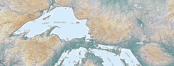
The Raven Great Lakes wall map shows what is probably the most easily recognized geographic feature in the United States, and the world’s largest set of fresh water lakes. Their shapes were memorably described by H.C. Hollings in “Paddle to the Sea”: Lake Superior a wolf’s head, with Isle Royale the animal's narrow eye; Lake Huron a voyageur, bending over under the weight of his (Georgian Bay) pack. As I recall, Erie and Ontario were bundles of furs, ready for the canoes. Lake Michigan, less stirringly, a squash. Collectively they are the core of an obvious region.
How far does that region extend? And, how much geographic context is helpful? Lake Nipigon certainly belongs in the map, and that sets a minimum northern boundary encompassing a lot of the Hudson Bay basin low country. We were tempted— isn’t the relationship between the Great Lakes and Hudson Bay worth showing? Yes, it’s interesting— but the visual distraction turned out to be annoying.
_1543959809.jpg)
The eastern boundary needed to include the Ottawa River and Montreal, and we’d have liked to extend a little further down the St Lawrence, but that would have opened up more of Delaware Bay in the southeast corner— another distraction. What about the western boundary? That was trickier, but in the end Lake of the Woods won out. Americans are used to seeing it on maps of the US as the odd “bump” at the east end of the 49th parallel portion of the border. It also marks the boundary between Ontario and Manitoba.
In physical geography, the drainage through the Rainy River and Lake of the Woods into Lake Winnipeg defines an important Mid-continent divide. The low elevations of the western basin barely appear at the northwest corner of the map, a reminder of the character of the territory beyond the map neat line. Whether that improves the map is the kind of question that keeps cartographers awake at night, but in the end it’s a matter of personal preference.
Regions may be geological, in some measure, but they aren’t set in stone.
4/4/18
